Qingpu HSI Dataset: A High-Resolution Hyperspectral Dataset
for Fine-Grained Land Cover Classification
1. Description
The Qingpu Hyperspectral Imaging (HSI) dataset is a large-scale, high-resolution remote sensing resource, specifically designed for fine-grained land cover classification and hyperspectral semantic segmentation research. Acquired through rigorous calibration protocols and annotated with pixel-level precision, we hope this dataset can serve as a new benchmark for image-based (patch-free) hyperspectral semantic segmentation studies.
The airborne HSIs were captured in Qingpu District, which is an outer suburb of Shanghai, China on June 16, 2022, using the Airborne Multi-Modality Imaging Spectrometer (AMMIS) developed by the Shanghai Institute of Technical Physics at the Chinese Academy of Sciences. The visible and near-infrared (VNIR) module of AMMIS utilizes a 256-band sensor (400–1000 nm). After removing five bad bands, 251 bands were ultimately used for analysis. A fixed-wing aircraft equipped with the AMMIS sensor captured HSIs at 3000 m altitude with a of 0.75 m spatial resolution. We conducted dark current correction, radiometric calibration, and geometric calibration on the HSIs. For the specific steps, please refer to Niu et al. (2024).
Technically, the proposed Qingpu HSI dataset features a data dimension of 20,480 × 2,944 pixels, with a spatial resolution of 0.75 m/pixel. It covers a spectral range of 400-1000 nm and achieves a spectral resolution finer than 0.5 nm, thereby embodying dual high-fidelity characteristics in both high spatial resolution and high spectral domains. Ground truth was established through comprehensive field investigation using the Xingse mobile application (version 3.16), identifying 20 distinct land-cover types and their spatial distributions. Fig. 1. shows the true-color image of the Qingpu HSI dataset and the corresponding ground truth.


2. Classification samples
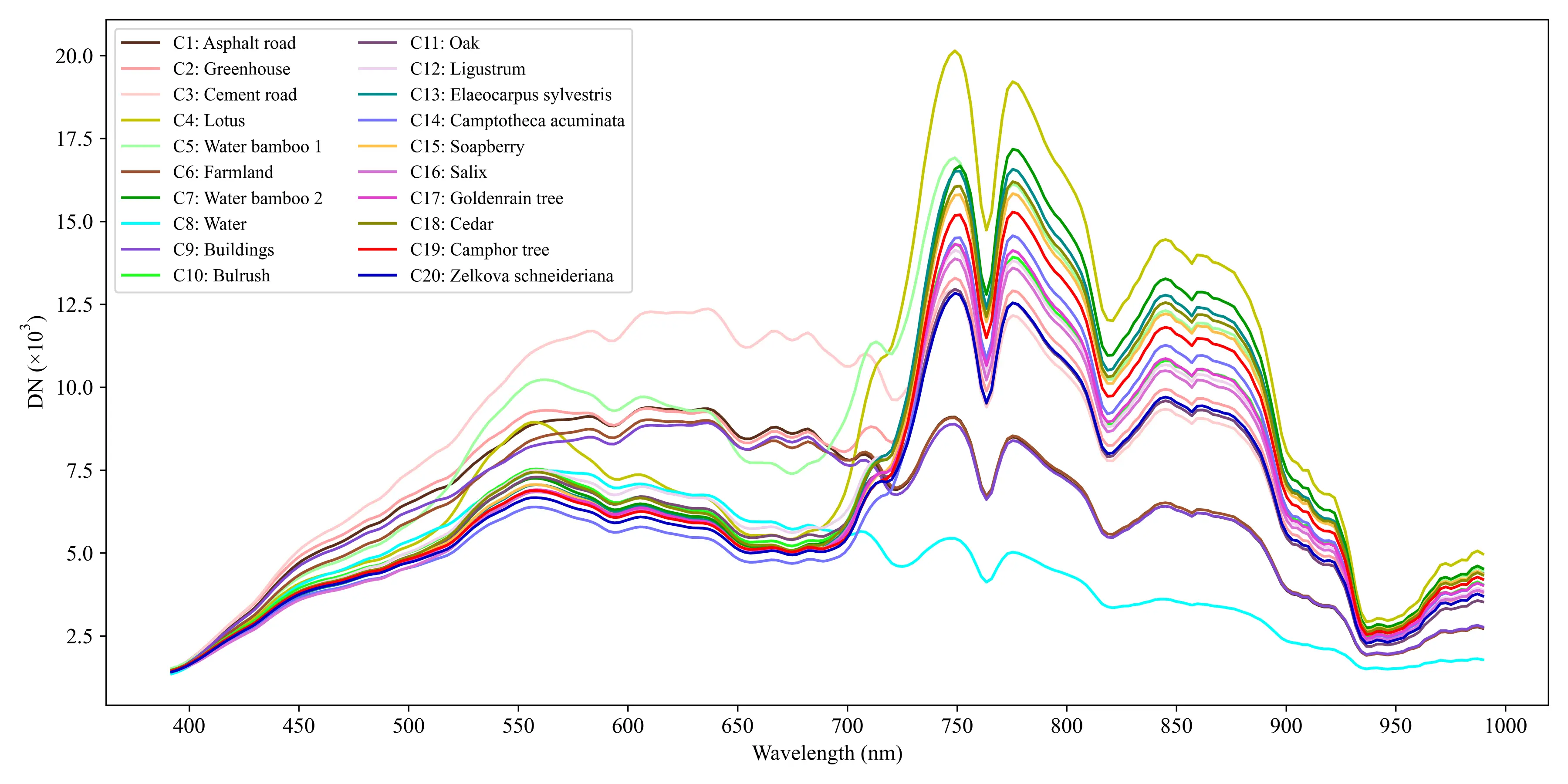
The resulting Qingpu HSI dataset comprises 20 land-cover categories, including four artificial surfaces, five crop types, ten tree species, and water bodies. The specific ground object types and sample quantities are detailed in Table 1, and Fig. 2 presents the mean digital number (DN) values of the spectral signatures for the 20 land-cover types.
| No. | Classes | Samples | No. | Classes | Samples |
|---|---|---|---|---|---|
| C1 | Asphalt road | 399657 | C11 | Oak | 28639 |
| C2 | Greenhouse | 360027 | C12 | Ligustrum | 34240 |
| C3 | Coment road | 403094 | C13 | Elaeocarpus sylvestris | 61276 |
| C4 | Lotus | 1478168 | C14 | Camptotheca acuminata | 25766 |
| C5 | Water bamboo 1 | 1762781 | C15 | Soapberry | 83168 |
| C6 | Farmland | 7355982 | C16 | Salix | 28949 |
| C7 | Water bamboo 2 | 2079988 | C17 | Goldenrain tree | 54603 |
| C8 | Water | 14989317 | C18 | Cedar | 123067 |
| C9 | Buildings | 1860528 | C19 | Camphor tree | 506583 |
| C10 | Bulrush | 102583 | C20 | Zelkova schneideriana | 10655 |

3. Download
We hope that the release of the Qingpu HSI dataset can promote the development of image-based (patch-free) hyperspectral semantic segmentation studies. Please fill in a simple questionnaire before downloading, which will appear after clicking the download link.
4. Copywrite
The copywrite belongs to Space-Sky-Surface Observation for GeoAI (3SOBS) academic research group, the Key Laboratory of Spatial-Temporal Big Data Analysis and Application of Natural Resources in Megacities (Ministry of Natural Resources), East China Normal University, Shanghai, China. The Qingpu HSI dataset only can be used for academic purposes, but any commercial use is prohibited. All users must comply with applicable laws and regulations of the People's Republic of China governing data usage and intellectual property. If you intend to build a new dataset based on this data, please contact us in advance. Distribution on other platforms is prohibited except for the download links we have published. Otherwise, we reserve the right to pursue legal responsibility.
If your research uses our dataset, please consider citing our paper.
[1] Ji R, Tan K, Wang X, et al. PatchOut: A novel patch-free approach based on a transformer-CNN hybrid framework for fine-grained land-cover classification on large-scale airborne hyperspectral images[J]. International Journal of Applied Earth Observation and Geoinformation, 2025, 138: 104457. 📖
[2] Niu C, Tan K, Wang X, et al. A semi-analytical approach for estimating inland water inherent optical properties and chlorophyll a using airborne hyperspectral imagery[J]. International Journal of Applied Earth Observation and Geoinformation, 2024, 128: 103774. 📖
5. Acknowledgment
We would like to extend our sincere gratitude to the Shanghai Institute of Surveying and Mapping for their provision of the airborne hyperspectral imagery data. Furthermore, we deeply appreciate the invaluable assistance of our laboratory members in the labeling process for the Qingpu HSI dataset.
6. Contact
If you have any the problem or feedback in using the Qingpu HSI dataset, please contact:
Prof. Kun Tan: tankuncu@126.com
Mr. Renjie Ji: ecnu.jirenjie@gmail.com
