Resources
Software
高光谱遥感智能处理与反演软件(中文版)
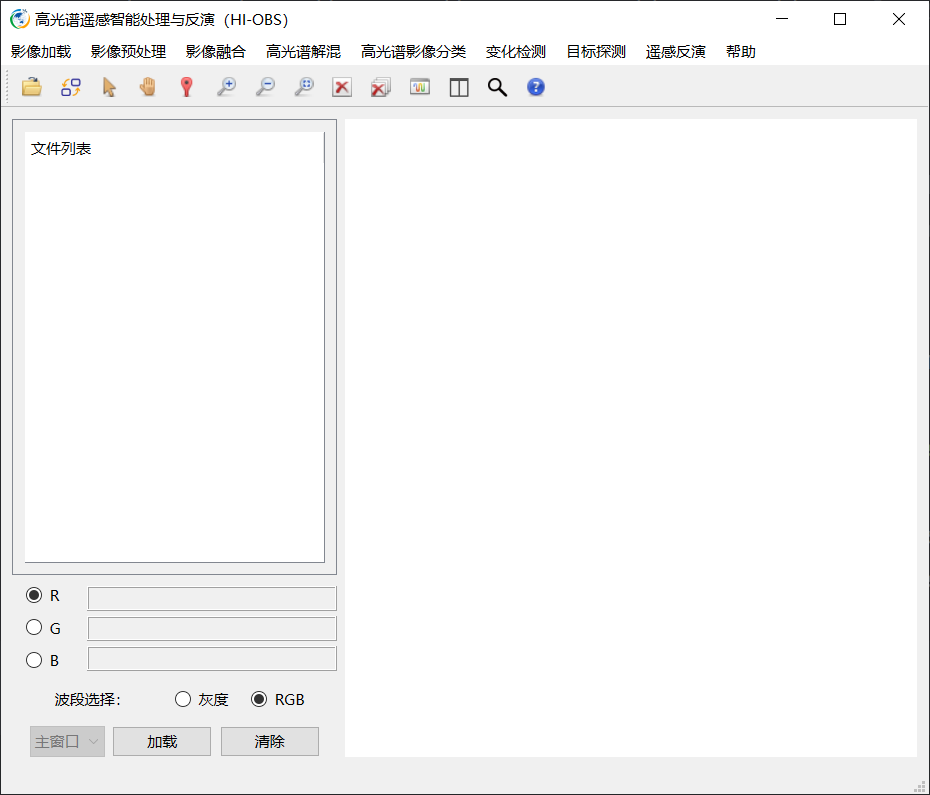
高光谱遥感智能处理与反演软件(HI-OBS)是一款由华东师范大学谭琨教授团队研发、上海市测绘院副院长赵峰领导实际测试和应用验证的高光谱遥感数据处理的专业软件,具备完全自主产权,程序高度可控。软件涵盖影像预处理、影像融合、高光谱分类、变化检测、目标探测、遥感反演等多个模块,能够针对航天、航空等多源异构遥感影像,提供全方位的处理、解译、信息提取和专题制图等一体化解决方案。

图1 软件主界面
The Hyperspectral Remote Sensing Intelligent Processing and Inversion Software(HI-OBS)
The Hyperspectral Intelligent Processing and Inversion Software (HI-OBS) is a specialized software targeted at hyperspectral remote sensing data processing, developed by the team led by Professor Kun Tan from East China Normal University and practically tested and validated under the direction of Zhao Feng, the Deputy Director of the Shanghai Surveying and Mapping Institute. The software is fully proprietary and allows for high-level programmatic control. It encompasses various modules including image preprocessing, image fusion, hyperspectral image classification, change detection, target detection, and hyperspectral inversion. The software is capable of making comprehensive processing, interpretation and extraction on multi-source remote sensing imagery from aerospace and aviation platforms. And with the help of HI-OBS, the results can be presented as integrated thematic maps.

Figure 1 Main Interface
Dataset
Qingpu HSI Dataset: A High-Resolution Hyperspectral Dataset for Fine-Grained Land Cover Classification
Introduction:
The Qingpu Hyperspectral Imaging (HSI) dataset is a large-scale, high-resolution remote sensing resource, specifically designed for fine-grained land cover classification and hyperspectral semantic segmentation research. Acquired through rigorous calibration protocols and annotated with pixel-level precision, we hope this dataset can serve as a new benchmark for image-based (patch-free) hyperspectral semantic segmentation studies.
The airborne HSIs were captured in Qingpu District, which is an outer suburb of Shanghai, China on June 16, 2022, using the Airborne Multi-Modality Imaging Spectrometer (AMMIS) developed by the Shanghai Institute of Technical Physics at the Chinese Academy of Sciences. The visible and near-infrared (VNIR) module of AMMIS utilizes a 256-band sensor (400–1000 nm). After removing five bad bands, 251 bands were ultimately used for analysis. A fixed-wing aircraft equipped with the AMMIS sensor captured HSIs at 3000 m altitude with a of 0.75 m spatial resolution. We conducted dark current correction, radiometric calibration, and geometric calibration on the HSIs. For the specific steps, please refer to Niu et al. (2024).
Technically, the proposed Qingpu HSI dataset features a data dimension of 20,480 × 2,944 pixels, with a spatial resolution of 0.75 m/pixel. It covers a spectral range of 400-1000 nm and achieves a spectral resolution finer than 0.5 nm, thereby embodying dual high-fidelity characteristics in both high spatial resolution and high spectral domains. Ground truth was established through comprehensive field investigation using the Xingse mobile application (version 3.16), identifying 20 distinct land-cover types and their spatial distributions. Fig. 1. shows the true-color image of the Qingpu HSI dataset and the corresponding ground truth.


Fig. 1. The true-color images and the corresponding ground truths of the Qingpu HSI dataset. (R:117, G:70, B:35)
Qingpu 异常探测数据集
简介:
Qingpu数据集是利用机载多模块成像光谱仪(Airborne Multimodular Imaging Spectrometer,AMMIS)在上海市青浦区获取,空间分辨率为0.75米,波长范围为400-1000nm,包含250个波段。通过对原始条带数据进行大气校正、辐射校正、影像裁剪等预处理,获取异常目标探测数据集。Qingpu-I数据集的大小为600×400像素,背景地物包含水体、植被、道路、裸土等,其中4辆车辆被视为异常目标,共计253个像素,占比0.16%。Qingpu-II数据集的大小为740×400像素,背景地物为道路、植被、建筑物、裸土、水体等,蓝色屋顶为异常目标,共计253个像素,占比0.16%。
参考文献:
[1] Wang Zhiwei, Tan Kun, Wang Xue, et al. Leveraging Multi-Class Background Description and Token Dictionary Representation for Hyperspectral Anomaly Detection[J]. Pattern Recognition, 2026, 169:11945.
[2] Wang Zhiwei, Tan Kun, Wang Xue, et al. Hyperspectral Target Detection Based on a Background-Aware Sparse Transformer Network[J]. IEEE Transactions on Geoscience and Remote Sensing, 2025, 63:1-19.
下载链接:
Kansas AHSI dataset: GF-5 hyperspectral benchmark datasets for classification
Introduction:
The Kansas AHSI dataset was collected by the visible-SWIR AHSI designed by the Shanghai Institute of Technical Physics, Chinese Academy of Sciences, which was one of the main payloads onboard the GF-5 satellite. The Kansas AHSI dataset covers 330 spectral bands to characterize the solar reflective regime from 400 to 2500 nm. The spectral resolution is about 5 nm for the visible and near infrared (VNIR) region from 400 to 1000 nm, and 10 nm for the visible-shortwave infrared (SWIR) region from 1000 to 2500 nm. The spatial resolution is around 30 m. The dataset was acquired over Kansas in USA in November 2018. The dataset size is 650×340 pixels. After geometric correction, radiometric correction, and other preprocessing, the interior objects in the study area were divided into seven categories by referring to Google Earth images of the same period and place. This dataset contains many crossroads and regular town districts, which can be used to demonstrate the visual performance of the different classification models. The specific ground features of the Kansas AHSI dataset are shown in Fig. 1 and Table. 1. The research was published in IEEE TRANSACTIONS ON GEOSCIENCE AND REMOTE SENSING.

Fig. 1. Pseudo-color composite image and the corresponding ground truth for the Kansas AHSI dataset.
Table. 1. Number of labeled pixels in each class in the Kansas AHSI dataset
| No. | Class name | Labeled sample number |
|---|---|---|
| C1 | Crop | 5203 |
| C2 | Meadow | 5468 |
| C3 | Business Area | 4695 |
| C4 | Bare Soil | 12088 |
| C5 | Residential Area | 8235 |
| C6 | Water | 1683 |
| C7 | Road | 4581 |
Copyright:
This dataset was made public by professor Kun Tan, from the Key Laboratory of Spatial-Temporal Big Data Analysis and Application of Natural Resources in Megacities (Ministry of Natural Resources), East China Normal University. The Kansas AHSI dataset can be used for academic purposes only and need to cite the following paper, but any commercial use is prohibited. Otherwise, we reserve the right to pursue legal responsibility.
Wang X, Tan K, Du P, et al. A unified multiscale learning framework for hyperspectral image classification[J]. IEEE Transactions on Geoscience and Remote Sensing, 2022, 60: 1-19.
武复宇,王雪,丁建伟等.高光谱遥感影像多级联森林深度网络分类算法[J].遥感学报,2020,24(04):439-453. [In Chinese]
Download Links:
We hope you can fill in a simple questionnaire before proceeding with the download, which will appear after clicking the download link.
Paper Download: 高光谱遥感影像多级联森林深度网络分类算法、A unified multiscale learning framework for hyperspectral image classification
Data Download:Kansas_AHSI_GF-5.zip
Xuzhou HYSPEX dataset:Airborne hyperspectral benchmark datasets for classification
The Xuzhou dataset was collected by an airborne HYSPEX hyperspectral camera over the Xuzhou peri-urban site in November 2014. This dataset consists of 500 × 260 pixels, with a very high spatial resolution of 0.73 m/pixel. The number of spectral bands used in the experiment was 436, after removing the noisy bands ranging from 415 nm to 2508 nm. The scene is peri-urban and is characterized by nine categories, including crops, vegetation, man-made structures, and coal fields The very high spatial resolution and the complex mixed categories make this dataset a challenging dataset for classification.
If you think it helpful, we would appreciate if you cite these papers in your work.
Tan K , Wu F , Du Q , et al. A Parallel Gaussian–Bernoulli Restricted Boltzmann Machine for Mining Area Classification With Hyperspectral Imagery[J]. IEEE Journal of Selected Topics in Applied Earth Observations and Remote Sensing, 2019:1-10.
Wang X, Tan K, Du Q, et al. Caps-TripleGAN: GAN-Assisted CapsNet for Hyperspectral Image Classification[J]. IEEE Trans. Geoscience and Remote Sensing 2019, 1–14.
Instructions:
The file declaration:
1.“classification image.jpg”: The jpeg format of ground truth.
2.“Pseudocolor image.jpg”: The jpeg format of pseudocolor.
3.“image.hdr”/“image.img”: The raster data format of the Xuzhou HYSPEX dataset.
4.“true label.hdr”/“true label.img”: The raster data format of the ground truth。
5.“data.mat”: the matlab format of this dataset. The variable “all_x” and “all_y” represents the spectral vector and the corresponding label respectively of the whole pixels (13000). The unclassified pixels are labeled as 0 in “all_y”; The variable “x” and “y” represents the spectral vector and the corresponding label respectively of the all labeled pixels(68877).
Data Introduction:XUZHOU HYSPEX DATASET
Paper Download: A Parallel Gaussian–Bernoulli Restricted Boltzmann Machine & Caps-TripleGAN
Data Download:HYSPEX_XuZhou.zip
NPP dataset in China
If you are interested in the National NPP, please contact us by email. All scholars and peers studying NPP in China have free access to the data which should not be put into commercial use. Our research group holds the final right to publish the data, and please cite the following papers
引用格式:Wang X, Tan K, Chen B, et al. Assessing the spatiotemporal variation and impact factors of net primary productivity in China[J]. Scientific Reports, 2017, 7(1): 44415.
Radiometric calibration
Calibration coefficients for the GF-5 AHSI hyperspectral sensors
Collaborated with the developer of GaoFen-5 (GF-5) hyperspectral satellite, the research group has successfully produced series of calibration coefficients for the hyperspectral sensors and published several relevant academic papers. If you are interested in putting the calibration coefficients into practice, please feel free to download and utilize them. Friendly reminder: these calibration coefficients represent scientific research achievements and are exclusively for scientific research purposes (please adhere to the citation format provided). Any commercial application is strictly prohibited.
标题: Vicarious Calibration for the AHSI Instrument of Gaofen-5 With Reference to the CRCS Dunhuang Test Site
作者: Kun Tan, Xue Wang, Chao Niu, Feng Wang, Peijun Du, Dexin Sun, Juan Yuan, Jing Zhang
引用格式:Tan K, Wang X, Niu C, et al. Vicarious Calibration for the AHSI Instrument of Gaofen-5 With Reference to the CRCS Dunhuang Test Site[J]. IEEE Transactions on Geoscience and Remote Sensing, 2020. DOI: 10.1109/TGRS.2020.3014656.
论文下载:Gaofen-5 Vicarious Calibration.pdf
数据下载:Gaofen-5 gains.zip
Radiometric cross-calibration of the ZY1-02D hyperspectral imager using the GF-5 AHSI
The research group introduces a cross-calibration method to calibrate the ZY1-02D hyperspectral imager using the well-calibrated Gaofen-5 Advanced Hyperspectral Imager. The 6S radiative transfer model is selected to simulate the apparent reflectance of the two hyperspectral sensors, and the calibration coefficients are calculated by spectral channel matching. This method could be used as an effective supplement to the on-orbit calibration method, and could also be extended to other satellite hyperspectral imagers. If you are interested in putting the calibration coefficients into practice, please feel free to download and utilize them. Friendly reminder: these calibration coefficients represent scientific research achievements and are exclusively for scientific research purposes (Please adhere to the citation format provided). Any commercial application is strictly prohibited.
标题: Radiometric cross-calibration of the ZY1-02D hyperspectral imager using the GF-5 AHSI imager
作者: Chao Niu, Kun Tan, Xue Wang, Bo Han, Shule Ge, Peijun Du, Feng Wang
引用格式:Niu C, Tan K, Wang X, et al. Radiometric cross-calibration of the ZY1-02D hyperspectral imager using the GF-5 AHSI imager[J]. IEEE Transactions on Geoscience and Remote Sensing, 2021, 60: 1-12.
论文下载:ZY1-02D cross-calibration method.pdf
数据下载:ZY1-02D gains.zip
